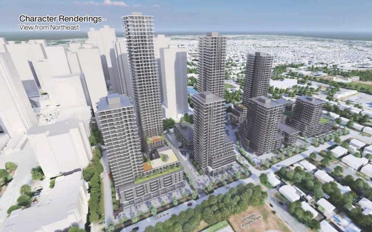
Earlier this month, the City of Coquitlam launched public engagement on its proposed land uses in transit-oriented areas (TOAs), as it continues to work towards implementing the Province's transit-oriented areas legislation (Bill 47).
The City is taking a phased approach to implementing the legislation. The first phase entailed designating the transit-oriented areas within 800 metres of SkyTrain stations and eliminating minimum parking requirements in those TOAs. Accounting for that radius, Coquitlam has eight TOAs, pertaining to Braid, Burquitlam, Coquitlam Central, Inlet Centre, Lafarge Lake-Douglas, Lincoln, Lougheed Town Centre, and Moody Centre Station.
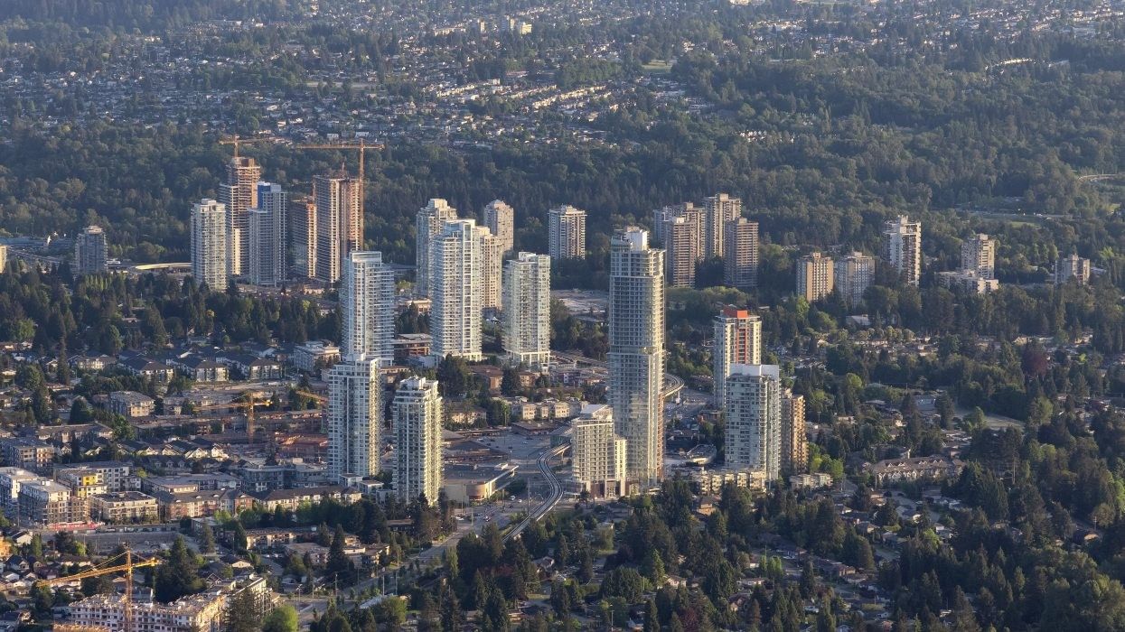
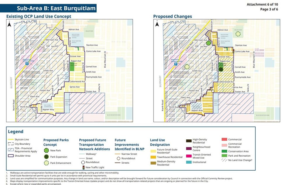
The second and third stage will then be focused on aligning provincial regulations with the City's own planning and updating land use plans accordingly. The second stage is focused primarily on the Southwest region of Coquitlam, including the Burquitlam Station TOA and Lougheed Town Centre TOA, as well as several adjacent shoulder areas and corridors.
Because the provincial TOAs are near-perfect circles, they could potentially result in parcels getting orphaned or cut off, said City of Coquitlam GM of Planning & Development Andrew Merrill in an interview with STOREYS last week. To remedy this, the City has taken the magnifying glass to these areas over the last year and made adjustments to account for property lines and various other factors.
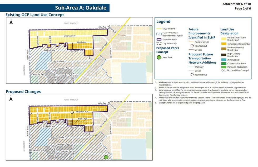
Some areas in the outer ring (Tier 3) of the TOAs that were previously designated for townhouses have now been designated for medium-density apartments to comply with Bill 47, which meant the City lost some areas that were previously designated for townhouses. To make up for that loss and to serve as a smoother transition from six-storey apartments to small-scale residential, the City is proposing that a few shoulder areas just outside of the TOAs be designated for townhouses — one area to the north of the Burquitlam TOA (Oakdale), one to the east of the Burquitlam TOA (East Burquitlam), and one to the east of the Lougheed TOA (West Austin).
"We previously had a lot of land, in what would now be Tier 3, designated for townhouse," said Merrill. "Because we lost that, we're now looking at high-rise in Tier 1 and 2 and then medium-density apartment in Tier 3, where do we sort of replicate that townhouse form? Particularly in a context like Coquitlam, a big family-friendly community, we want those larger-sized family-friend townhouse units aside from all the apartments that we're going to get in transit-oriented areas."
"We find, in Coquitlam, a lot of challenges between the too-small apartment and the too-expensive house at the other end," he added. "In a market like Coquitlam, townhouses are that sort of sweet spot, where you can get the space you need for your family, but still at a relatively more affordable price. That's why we would certainly want to encourage them in some of these shoulder and corridor areas that are near frequent transit."
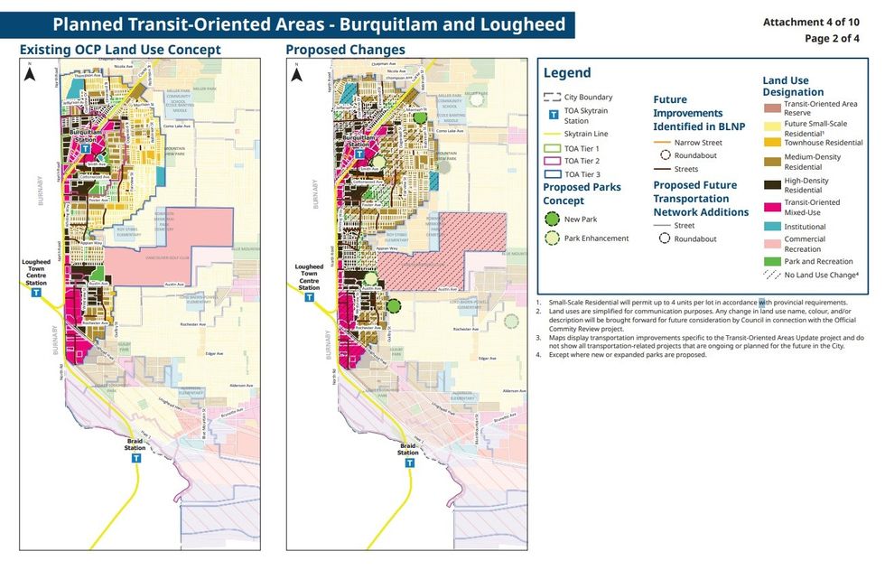
Proposed land use changes for the Burquitlam and Lougheed Town Centre TOAs. / City of Coquitlam
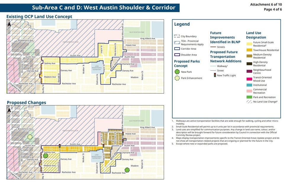
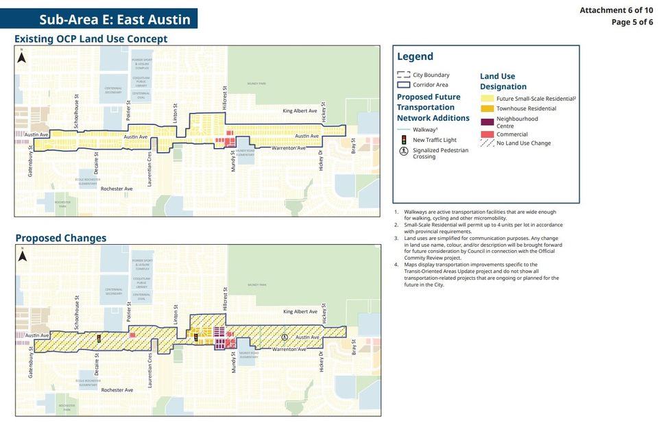
Then there are the long corridors that are further away from the TOAs and shoulder areas, but are nonetheless major arterial roads that provide some opportunity for low-density development. These corridors include the West Austin and the East Austin corridors that represent the two ends — separated by several blocks — of Austin Avenue, as well as the stretch of Como Lake Avenue between Townley Street and Wilmot Street.
In these three corridors, most of the areas are designated for small-scale residential, but the City has proposed that small portions of those areas be designated for townhouses, commercial, and mixed-use, in order to create some mini-nodes.
"For us, that Neighbourhood Centre designation accommodates a six-storey mixed-use building," said Merrill. "So similar to what you see on arterials in other parts of the region like Hastings Street in Burnaby or some of the major arterials in Vancouver, we've got ground-floor commercial and then five floors of apartments above. That's really to provide some additional housing options near frequent transit on those arterials and also to provide some local shops and amenities within walking distance."
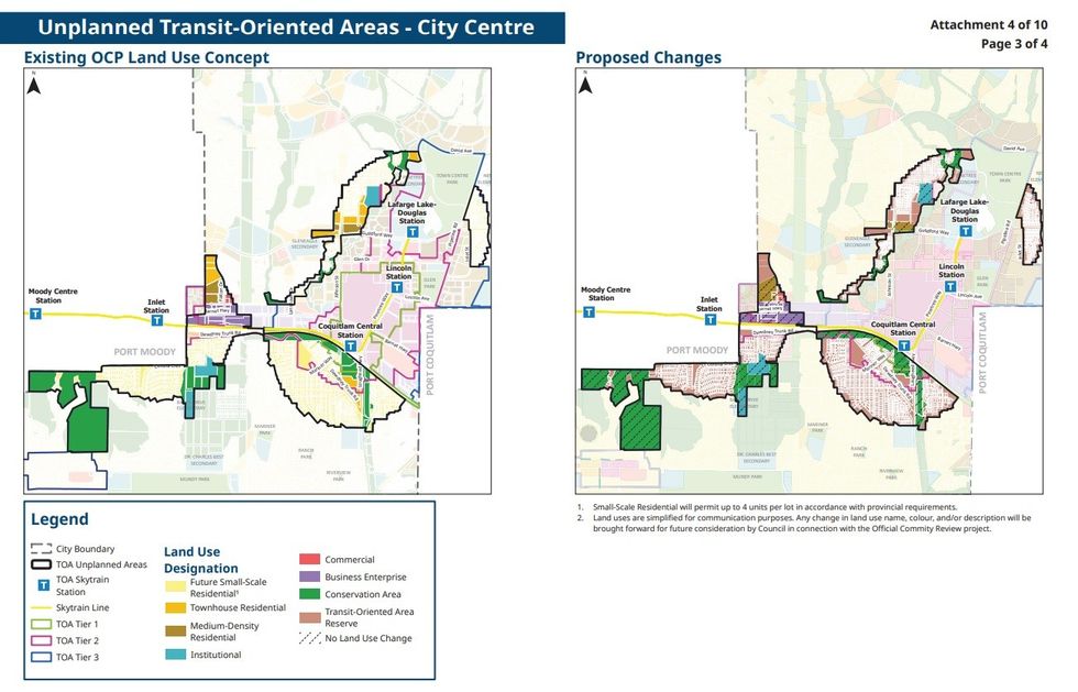
The aforementioned areas are all what the City is calling "planned" transit-oriented areas, which are areas where the City was already planning for transit-oriented development prior to the Province's introduction of Bill 47 in Fall 2023. The City Centre planned transit-oriented area that includes the Coquitlam Central Station TOA, the Lincoln Station TOA, and the Lafarge Lake-Douglas Station TOA are currently not subject to any proposed changes, because the existing land use designations already allow for the same or higher density than what's required by Bill 47.
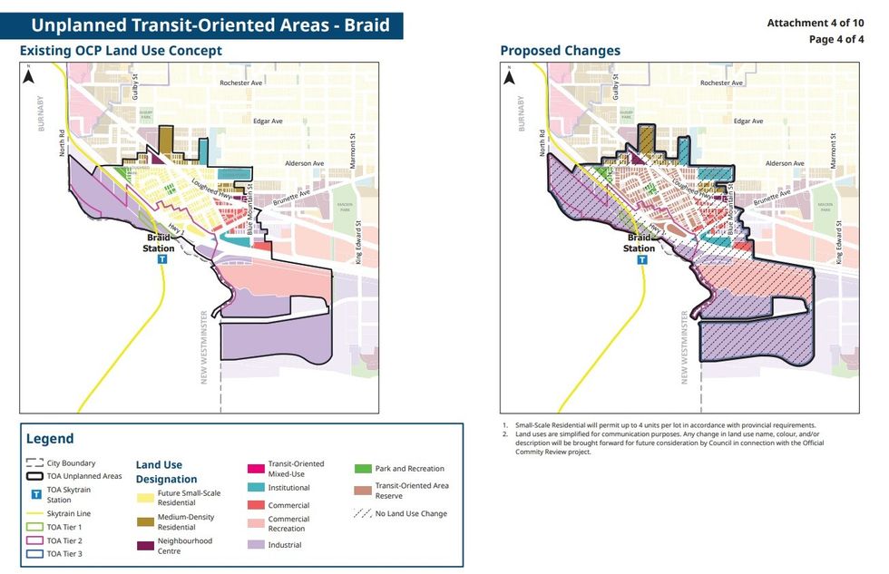
Several areas just outside of these City Centre TOAs, however, are considered "unplanned," including the large area to the south of Coquitlam Central Station and several areas that are part of TOAs radiating from the Moody Centre and Inlet Station TOAs in Port Moody. For now, the City is proposing that these areas be designated as "Transit-Oriented Area Reserve," as they take the magnifying glass to these areas over the next year like they did for Burquitlam and Lougheed over the past year. Precise land use designations will then be made public during the third stage.
"South of the CPR main line, south of Coqutilam Central Station, and the area around Braid Station north of the highway, and there's a couple of other pockets — we've never done comprehensive land use planning," said Merrill. "We weren't predicting a lot of land use change in the short-to-medium term in those areas. We hadn't studied the utility and transportation networks or amenity needs or land uses or consulted with the public about change in those areas, so we need to go through all of that work, so that we can facilitate proper development in the area, while also understanding what's needed to facilitate it. That will be part of Phase Three."
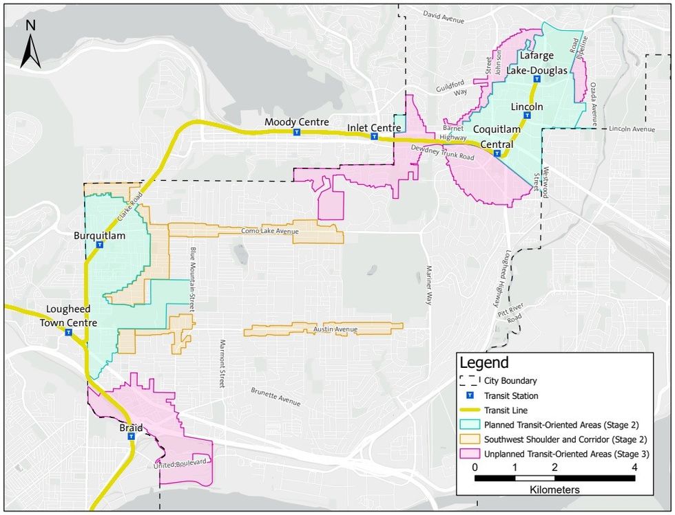 An overview of all of the transit-oriented areas, shoulders areas, and corridors in Coquitlam. / City of Coquitlam
If it sounds like there is some tension between the City and the Province and some work the City had previously done that was effectively rendered moot by provincial legislation, that's because there is, as Coquitlam City Council and other City officials — plus many in other municipalities as well — have openly said.
"Our land use designations for where we put high-density apartments and medium density and some townhouses were much more nuanced, based on the local conditions and the engagement we did and the background analysis we did through the neighbourhood planning process," Merrill added. "It wasn't perfect circles. It was based on the lot and block pattern and where there were bus networks. Then you overlay the Province's perfect circles on top of that and of course that didn't line up."
"The Province could have just said 'These perfect circles have an area of X, you need to designate X amount of land to meet growth,' but we could've massaged that based on local conditions. I think that would've been more effective."
Nonetheless, here we are, and public engagement for the aforementioned proposed land use changes is currently ongoing until July 14. This second phase is expected to be wrapped up by the end of the year, with Phase Three expected to begin afterwards.