Another eye-catching bridge has set sail for Toronto’s up-and-coming Port Lands neighbourhood, destined to play a key role in its anticipated transformation.
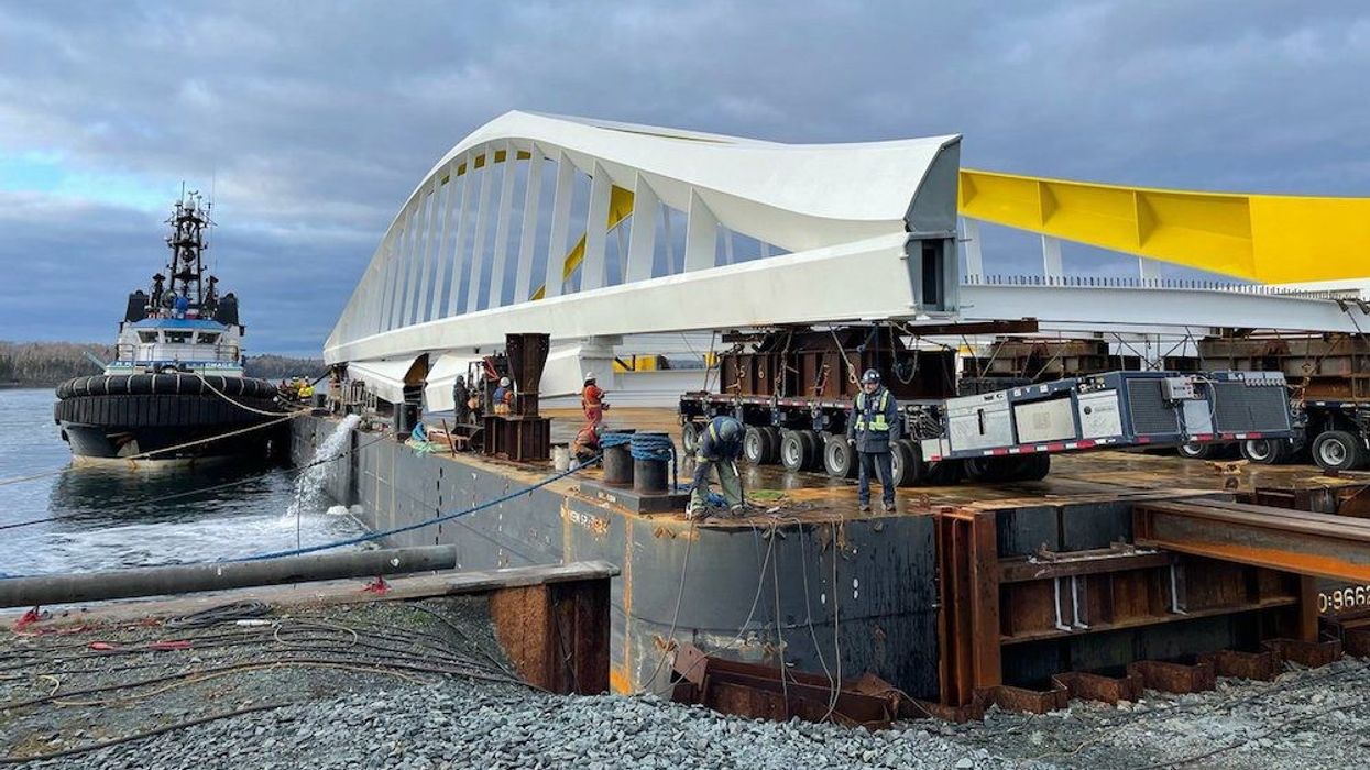
The Cherry Street South Bridge is one of four new futuristic bridges that will soon connect downtown Toronto to the future Villiers Island, the new island that will be created by extending the Don River through the Port Lands. The sleek white and yellow bridge is 70 metres long and weighs 830 tonnes.
“The Cherry Street South Bridge will cross what is currently Polson Slip and what will eventually be the new mouth of the Don River,” tweeted Waterfront Ontario earlier today, along with a photo of the anticipated bridge.
The Port Lands bridges are a central component in Waterfront Toronto’s much-buzzed-about $1.25-billion revitalization project, which is slated for completion in 2024. It will render the east waterfront flood-proof and transform the currently industrial and uninspiring wasteland south of Cherry Street and Lake Shore Boulevard East into a multi-faceted and green neighbourhood.
READ: Port Lands Revitalization to Include Waterfront Parks and Urban Play Areas
Two bridges have arrived already. In fall 2020, the first bridge -- which will serve as the Cherry Street North transit bridge -- like ones to follow, was loaded onto a barge in Dartmouth, Nova Scotia and floated up the St. Lawrence into Lake Ontario and then into Toronto harbour.
In May, the first half of the Commissioners Street Bridge arrived in Toronto’s harbour, and the second half followed in late August. At 152 metres long, the white and red Commissioners Street Bridge is the largest bridge built for the undertaking and will cross over a new river, connecting Commissioners Street to Don Roadway. Most notably, it will transport cars, bikes, and people to the new, flood-proof and eco-friendly Villiers Island.
The Cherry Street South Bridge will arrive in early December. The fourth bridge -- the last piece of the floating puzzle -- is scheduled to arrive in spring 2022 and will link the Cherry North bridge.
Villiers Island will materialize through the naturalization of the Don River, meticulous flood protection, and the formation of the new river mouth and outlet into Lake Ontario. In what will become a go-to destination year-round, Villiers Island will house new trails, parks, and green spaces. The 22-hectre area will also include a mixed-use residential development and new restaurants. The ambitious initiative will also include an elementary school, community centre, and non-profit childcare services.
As with the other two bridges, Waterfront Toronto is tracking the bridge’s journey from the country's east coast to its new home in the big city.